Carte IGN : « Haut Cians » TOP 25 n° 3640 OT 1:25.000e
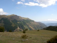
The Plateau Saint Jean Start at the Col Sainte Anne. Follow the B 32 straight towards the South.
At the chapel, high up on the hill, you will enjoy a 360° panorama. You
are most likely to come across herds of cows or flocks of sheep grazing on
the plateau. In Winter, the plateau is accessible from the Condamine
with snowshoes.
Easy walk: 1hr 15 – Ascent: 200 m; (600ft) – Waymarks: 57 – 57a – 70b
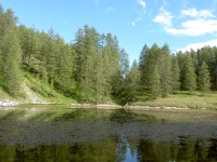
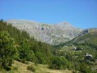
Lake of Beuil and Tête du Garnier, A concentration of all typical kinds of landscape found in the Cians Valley:
easy narrow paths winding through vast forests of larch trees, quiet vales leading to panoramas and high passes and the gentle ascents which
won’t do any harm to the hikers’ moral fibre or to their calf muscles !
Details of the route on the Conseil General website: » RandOxygene ».
Tête du Giarons
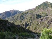
The Cians High Paths above the Gorges du Cians This is an original walk through the exceptional landscape of the Gorges
du Cians, preferably for well-equipped and well-trained hikers.
Route: Start from Beuil, take the Cians road, and at the spot called
”Pré de Chaudi » ( 1280 m. 3900 ft. – waymarked 67 ), ford the Cians stream and
take a small path on its left bank.
Details of the circuit on the Conseil General website : « RandOxygene ».
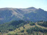
Mount Mounier (2818 m. – 8454 ft.) The massive presence of Mount Mounier dominates all the majesty of this whole mountainscape. The highest limestone massif in the Alpes Maritimes, it is one of the most impressive viewpoints in the Southern Alps.
Route : start at the Col de l’Espaul parking space ( 1748 m. – 5244 ft.- Waymark 7), follow the path to the hamlet of La Colle for 1 km ( 3/4 mile) to waymark 8
Details of the circuit on the Conseil Général website : « RandOxygene ».